If you are reading this you’ve probably already heard of the Transcontinental race and most likely read more than one blog post or other article about it. The writings probably had a section titled ”What is the Transcontinental race”. Great. Because you are about read one more. As a general disclaimer, everything you read here are my opinions and are in no way affiliated with the Transcontinental race.
Kirjoittajan arkistot:mkpaa
2016 brevet-kalenteri
Audax club Parisienin kansainvälinen brevet-kalenteri on saatavilla. Suomen kalenteriin on merkitty brevettien deadlinet.
Tällä kertaa on 3 täyttä sarjaa (200, 300, 400 ja 600) sekä 1000 km ja Fleche.
Talvipäivänseisaus 2015 – tulokset
Talvipäivänseisaus 2015 / mediatiedote
Mediatiedote 15.12.2015, vapaa julkaistavaksi
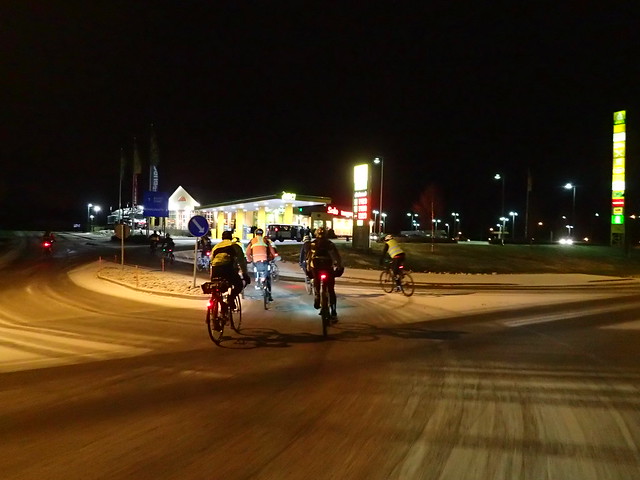
Vuoden pimein pyöräilytapahtuma, Talvipäivänseisaus, ajetaan 19.-20.12.2015. Pyöräilijät saavat lähteä liikkeelle mistä haluavat auringon laskiessa ja maalissa, joko Tampereella tai Oulussa, pitää olla auringon noustessa. Mukaan on lähdössä yli 40 pyöräilijää ympäri Suomea. Osallistujat ajavat yksin tai ryhmässä haluamaansa reittiä vähintään 150 km matkan.
Samalla käydään leikkimielinen kisa siitä kuka ajaa pisimmän matkan pisimpänä yönä. Viime vuonna pisimmät matkat olivat yli 300 km.
Talvipäivänseisaus järjestetään nyt kolmatta kertaa. Maalipaikkoina ovat Tampeella hotelli Ilves ja Oulussa hotelli Eden.
Lisätietoja:
Mikko Mäkipää
0505822386
mikko.makipaa@yahoo.com
www.randonneurs.fi
The Finnish Winter solstice ride
(updated 11.12.2016)
During winter days are short and nights long in Finland. In northest Finland, hunders of kilometers north of Polar circle, night lasts almost 5 weeks. Next sunrise is 16th of january. Below Polar circle there is 1 to 5 hours of sunlight on winter solstice.
Our Talvipäivänseisaus-pyöräily (Winter solstice ride) is sort of a DIY Fleche. A gathering to meet other cyclists. We have 2 finish lines. Participants may ride to either Tampere or Oulu. They may start riding when sun sets at finish line and have to finish before sun rises. Weather may vary. 2016 forecast for Tampere is cloudy and below 0 degrees celcius.
Rules are as follows:
- Minimum distance is 150 km
- Single stop may not be longer than 2 hours
- During last 2 hours you must ride atleast 15 km
- You may only ride a road once in same direction
- And as always, remember to use front and tail lights and wear a reflective vest
Rest is up to you. Ride in group or alone. Make your own route as you wish. Enjoy the 19+ hours of complete darkness and empty roads.
Ride will start next saturday, 17th of december, afternoon and finish sunday morning around 10 am. We are expecting over 40 riders to Tampere and a few to Oulu. You can follow #talvipäivänseisaus on Twitter during the event.
Kokemuksia ensimmäiseltä brevetiltä
Vastaa
Mika Helenius kirjoittaa kokemuksia ensimmäiseltä brevetiltään, Tuopin jäljet 200 km:lta.
Mun eka Brevet!
Noin kolme kesää aiemmin tein päätöksen ostaa kunnon maantiepyörä entisen retkipyörän loppuun kuluttua työmatkapyöräilyn ohessa. Päätös oli oikea. Ensimmäisenä kesänä mittariin pamahti n. 5000 km joista työmatkaa n. puolet, loput yksin suoritettujen retkipoljentojen myötä. Ilmoittauduin myös Tour de Helsinkiin 2013, mutta osallistuminen jäi flunssan takia.
Seuraavana kesänä kilometrejä kertyi maltillisemmin. Tour de Helsinkiin pääsi vihdoin osallistumaan 2014. Ryhmäajon salat aukesivat: Porukassa pääsee pidemmälle, kovempaa, helpommin. Työmatkat tuli taitettua läpi seuraavan olemattoman talven. Pyöräilystä oli tullut elämäntapa.
Intermodal cycling trip around Europe
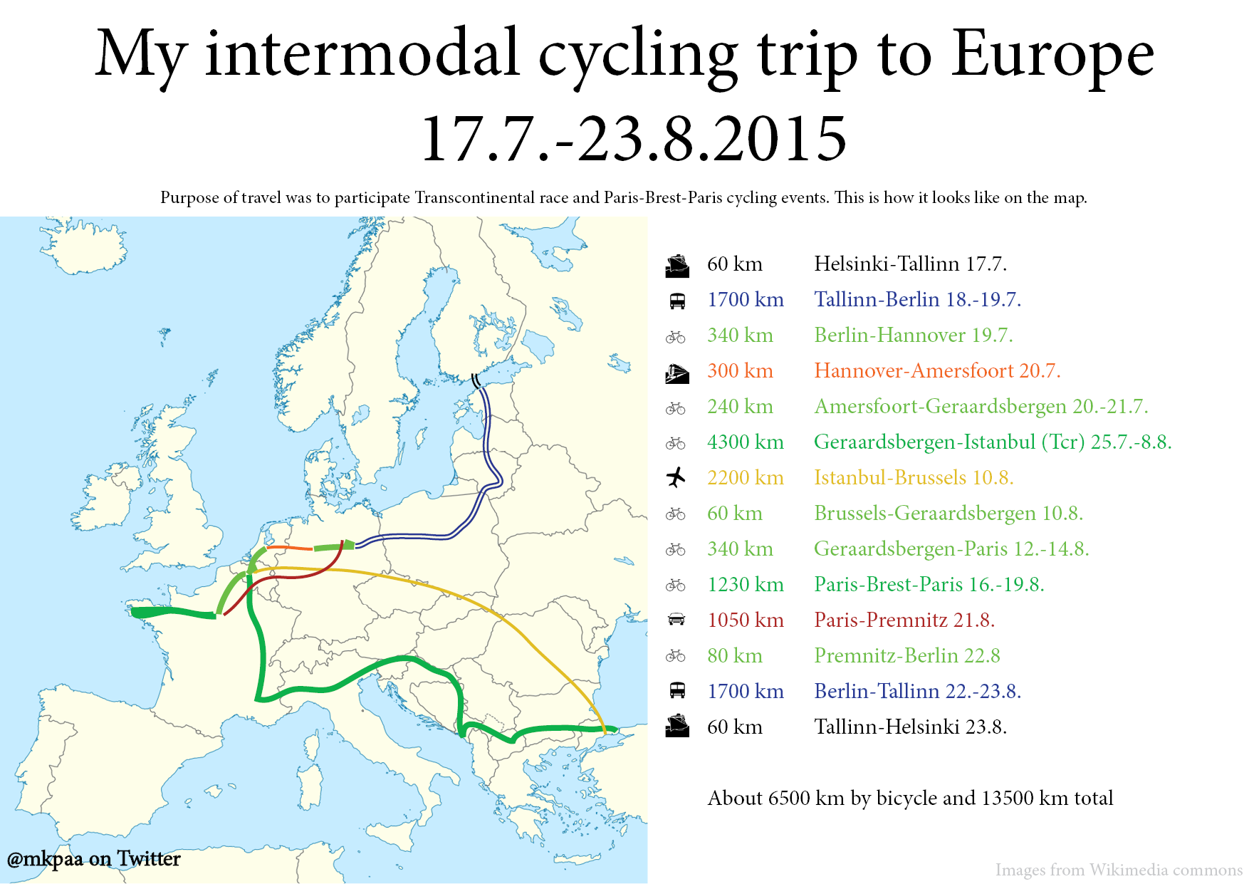
I did a five week trip to Europe to participate Transcontinental race and Paris-Brest-Paris. For a solo cyclist the logistics and planning this kind of trip takes quite a lot of effort. I have a “handicap” of flying only once per year (one take-off, one landing), primarily for ecological reasons. Another constraint is that I don’t have a driver’s license. Several people asked how exactly I managed the trip, so I wrote a rough outline of what I did and why.
Suomalaiset Paris-Brest-Parisissa 2015
Paris-Brest-Paris 1200 km brevet ajetaan 16.-20.8.2015. Lähdöt ovat kello 16 alkaen 15 minuutin välein riippuen lähtöryhmästä. Osallistujien etenemistä voi seurata tapahtuman sivulla. Sivu päivittyy sitä mukaan, kun ajajat saapuvat kontrolleille.
Laita viestiä esim. Twitter, Facebook, Fillarifoorumille tai kommentteihin, jos haluat nimesi ja numerosi listalle.
- Anssi Anonen (86h54min) L229
- Juha Hänninen (kesk) K254
- Timo Ikonen (65h01min) A178
- Sakari Isoniemi (79h13min) D124
- Ari Karjalainen (84h56min) R200
- Jan Kruse (67h39min) C114
- Eero Liimatainen (69h47min) G253
- Markus Marttila (83h59min) H258
- Ilpo Mikonmäki (86h54min) L228
- Samuli Mäkinen (58h29min) B123
- Mikko Mäkipää (67h40min) C253
- Paavo Nurminen (kesk) N221
- Sampsa Paalanen (83h25min) R207
- Antti Pietilä (72h40min) G251
- Sampsa Puikkonen (64h51min) G256
- Jorma Raitanen (88h0min) H252
- Jukka Ranta (kesk) L108
- Raimo Ruokonen (65h01min) A175
- Hannu Sainio (71h33min) B124
- Esa Salonen (65h01min) A176
- Jaakko Salonen (myöh) G254
- Jukka Salonen (86h19min) L231
- Matti Sievänen (65h01min) A179
- Antti Sintonen (65h22min) E129
- Pertti Stedt (67h40min) C109
- Antti Surokivi (88h05min) G252
- Heikki Tanskanen (87h10min) J065
- Esa Vainikainen (kesk) R338
Ajokuvia voi etsiä ajajien nimellä tai numerolla täältä:
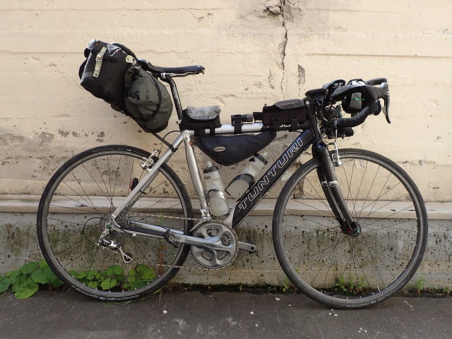
Transcontinental race 2015 – complete kit list
Another year, another Transcontinental race kit list. If you have followed my riding before, you’ve probably already read my 2014 kit list. I will occassionally refer to changes from last year.
More photos in Flick album.
I am riding my trustworthy old steed. Tunturi F500 frame from 2003 that has seen many incarnations from hybrid bike to frankenbike it is today. I changed tires from unreliable, but smooth (Vittoria open pave), to more reliable, but rough (Schwalbe Durano 25 mm). Rims were replaced and hence wheels rebuilt since last year. SON deluxe front dynamo hub and PowerTap rear hub.
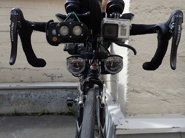
I am still afraid of the dark and am using the same setup of lights as last year. Busch&Muller Luxos U and B were both replaced as warrantry issues since last year. B had broken connector and U just stopped working. The newer model of U is better design, but has too-likely-to-get-lost external usb-port. In the scale of high impact to daily mileage, likely to get lost and impossible to replace this small cable is probably the worst.
MyTinySun is mostly for long uphills, where dynamo is useless, and rough downhills where backup light is very important.
GoPro 3+ and MyTinySun are mounted with KlickFix mounts. They are very steady and easy to use compared to most available mounts.
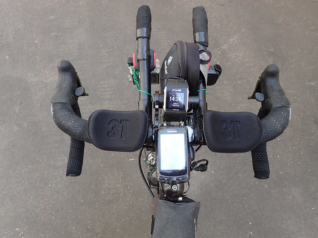
The big change since last year is 3T aerobars. I usually vow for simple and aesthetic dashboard, but couldn’t really get it any better. For reference here is last year’s setup.
Garmin 810 is the same old, best of the garbage. Polar CS600 was replaced with ”state-of-the-art” V800. V800 has its share of problems. Probably worst is no battery level indicator so you can’t even tell if it is charging or not. Also I haven’t been able to figure out when it runs out of memory. It is however stable enough that I should have my daily stats available at Polar flow.
The small bag will be used to hold powerbanks, rag, spork and small parts when neccessary.
Speaking of aesthetics. I was – this close to mounting 2nd B&M Secula to get symmetric rear view. Secula is always on to be visible and Niterider Solas is for blinding people behind me, should it be needed for some reason. It was also replaced since last year as warrantry issue as the old one drowned at Alps during last year’s Transcontinental race.
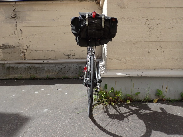
The front top tube bag is for food and the, my precious, B&M usb cable. The other bag is for tools and work glove.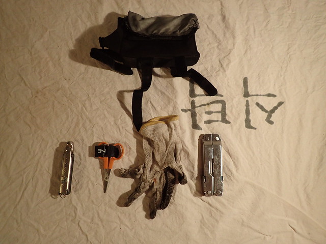 Triangle bag is for always needed extra clothes. Arm warmers, leg warmers, buff, shoe covers. Exactly the same as last year.
 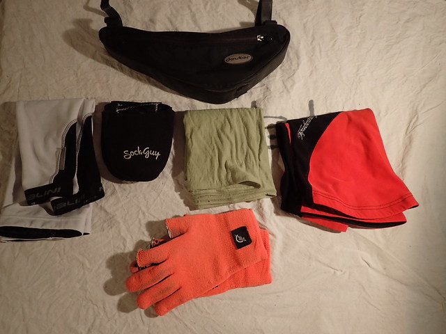 Tools are also pretty much the same as last year.
- 2 spare tubes
- 1 spare tire
- 2 pumps
- set of patches and tire lever
- multitool
- spare batteries for SPOT, Powertap and heart rate sensor, Powertap tool
- oil and rag
- cleat, BOA wire and tool
- spare connectors and cable for lights
- cable ties and tape
- 1 brake and 1 derailleur cable
- Garmin mount
- Chain links
nipples, spokes are in Carradice bag
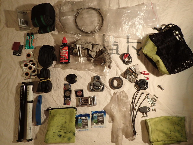 Tools are packed in Carradice bag’s main compartment.
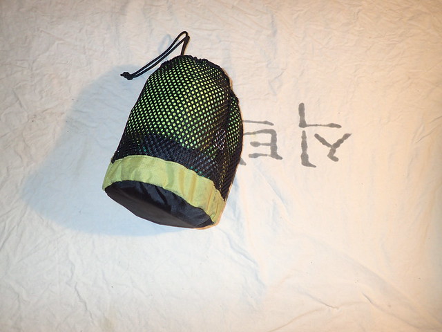
Also in the Carradice main compartment are the spare cloths, and some extra food. One pair of socks, Kalas mission jacket, bibs and Mavic Vision reflective wind vest.
In Alpkit bag under saddle there is bubble wrap for sleeping. Clothes to be used during breaks. I left shirt and shoes off from the list this year. Some shampoo, toothpaste, toothbrush, deodorant and razor.
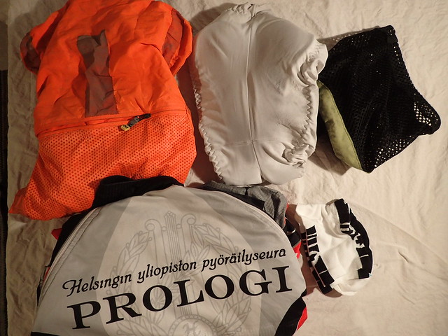
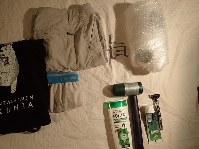 As I will not be using a hip bag this year there were some changes in the side pockets of Carradice. Right pocket Assos chamois cream, sun lotion, space blanket (not in photo) and Petzl Tikka 2 xp headlamp when not in use. Headlamp has GoPro mount retrofitted in it. Left pocket has packable backpack (lost my old one and got a waterproof Sea-to-Summit instead), cable lock, GorillaPod and bag of GoPro spares including extra battery.
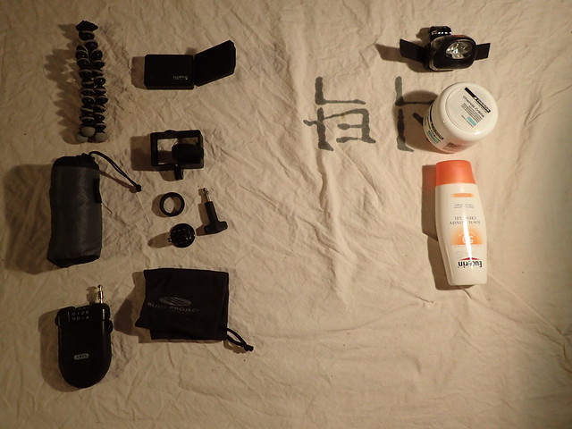
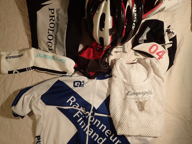
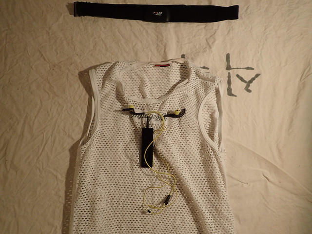
Finally the kit I’m actually wearing. Pretty much the same as last year. Sworks shoes, Assos gloves, shorts, jersey, cap (2014 edition in photo for obvious reasons :)) and Assos socks.
 As mentioned earlier I don’t have hip bag this year. Hence I had to make a few extra pockets to my jersey. One for documents and another for primary mobile phone.
Left rear pocket has secondary mobile and wallet. Middle pocket has 2 2x usb chargers, cables and occasionally a power bank in a homemade organizer packed in Ortlieb waterproof bag. Cables include 3x micro usb, 2x mini usb, 1x Olympus usb and 1x Polar V800. Polar V800 is another likely-to-get-lost-high-impact cable along with the B&M usb. Right pocket has Olympus TG-3 camera.
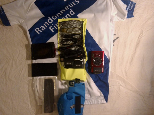 And same as it is used.
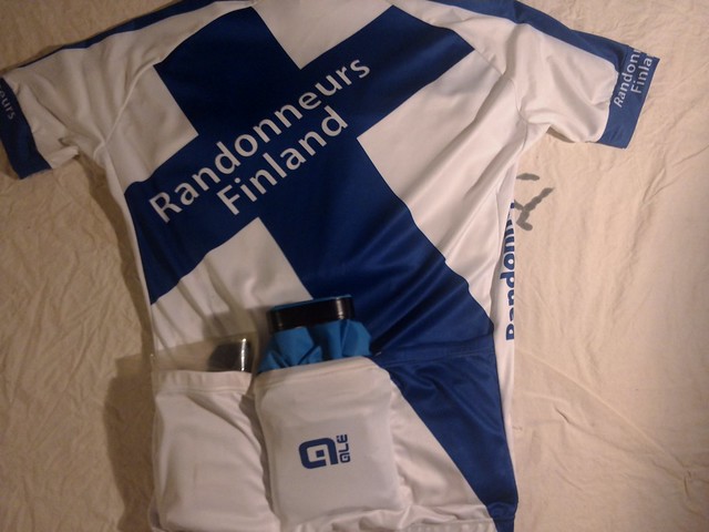
My undershirt has a homemade SBH-52 handsfree mount. It is easy to start and stop using the ear plugs with this setup.
 Most of the electronics in same photo. I have 3 power banks, Tespack also has solar charger, that are held where they happen to be needed.
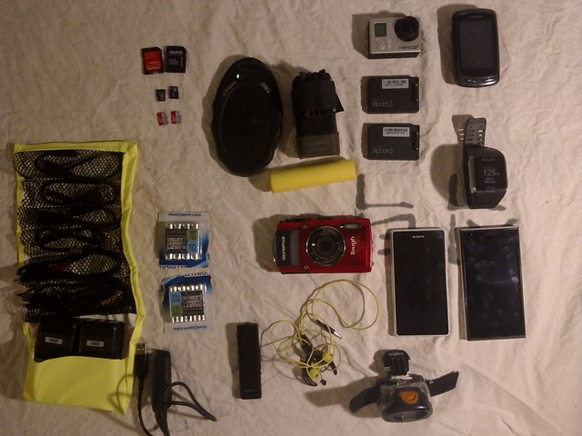
Mediatiedote: Transcontinental race pyöräily Belgiasta Istanbuliin
Tiedote (14.7.2015), vapaa julkaistavaksi
Transcontinental race 2015
Belgian Geraardsbergenistä Istanbuliin pyöräiltävä Transcontinental race alkaa keskiyöllä kello 0:00 lauantaina 24.7.2015. Matkaan lähtee noin 180 yksin ajavaa ja 20 paria. Kaikki ajavat itse tekemäänsä reittiä ja matkan aikana saa käyttää vain yleisesti saatavilla olevia palveluita kuten kauppoja ja hotelleja. Kaikki itse järjestetty huolto on kielletty. Pyöräilijät ajavat kilpaa sekä toisiaan että kelloa vastaan. Maalissa Rumeli Hisarin linnoituksessa Bosporinsalmen rannalla pitää olla viimeistään 14 päivää ja 22 tuntia lähdön jälkeen keskiyöllä lauantaina 8.8.2015
Matka on lyhimmillään yli 4000 kilometriä eli vähintään noin 300 kilometriä päivässä. Nopeimmat tulevat olemaan maalissa noin kymmenen päivää lähdön jälkeen.
Reitin tulee kulkea neljän kontrollipisteen kautta. Ensimmäinen kontrolli on Mont Ventoux Provencessa Ranskassa. Toinen on Strada dell’Assietta Italian Alpeilla. Kolmas on Vukovar Kroatian ja Serbian rajalla. Neljäs on Montenegrossa Kotorinlahden rannalla olevan Mont Lovcen vuoren huipulla.
Yleisö voi seurata tapahtumaa osoitteessa www.transcontinentalrace.com. Pyöräilijöillä on mukana seurantalaitteet, jotka päivittävät tilanteen verkkoon reaaliajassa. Päivittäiset raportit tapahtuman etenemisestä osoitteessa www.poljento.com.
Mukana on yksi suomalainen ajaja. Mikko Mäkipää, Helsinki (@mkpaa)
Lisätietoja Mikko Mäkipää / 0505822386